UAE off-road navigation for Range Rover drivers demands more than a capable vehicle. Whether you’re crossing the rolling red dunes of Liwa in the Rub’ al Khali, tackling the rocky switchbacks of Jebel Jais, or following gravel trails through Hatta, proper route planning with offline maps, GPX waypoints, and backup tools is what separates a great adventure from a dangerous situation.
Here’s a practical guide to planning and following off-road routes so you can explore the UAE confidently year-round.
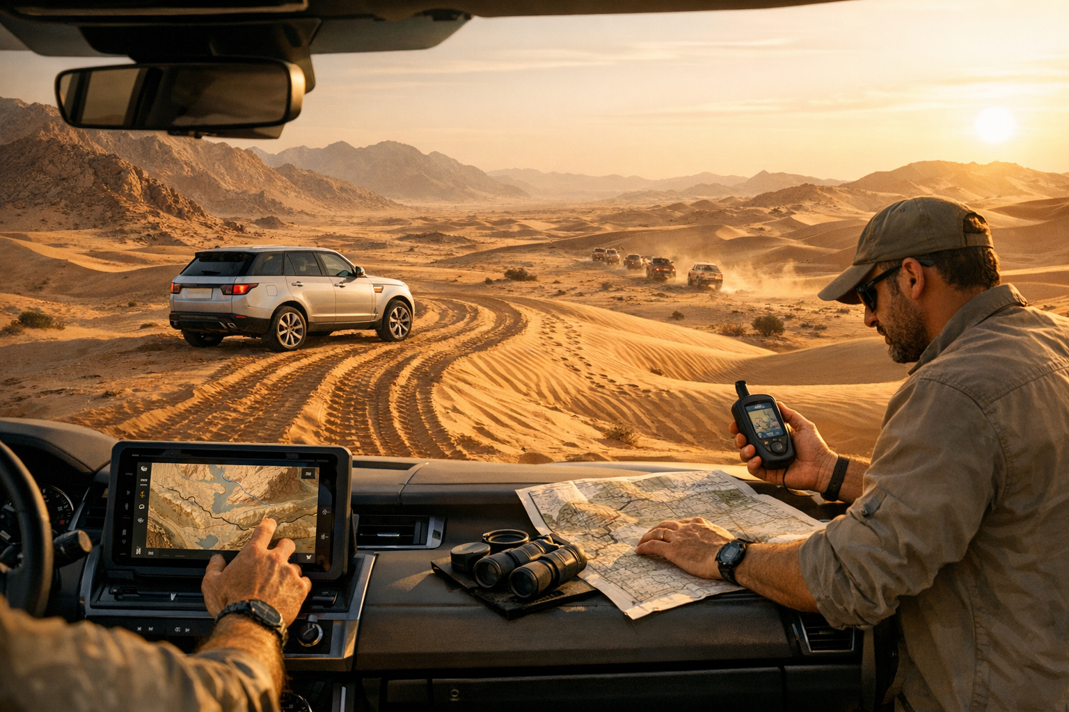
Why Offline Navigation Matters in the UAE Desert and Mountains
Mobile signal coverage in the UAE is excellent along highways and in urban areas, but once you venture into deep desert basins near Liwa, mountain wadis around Hatta, or remote border regions, connectivity drops quickly. Relying solely on Google Maps or Waze for desert driving near Dubai or anywhere off tarmac is a recipe for getting lost — or worse, stuck without any way to communicate your position.
Offline navigation ensures you always have access to your planned route, topographic detail, and critical GPX waypoints regardless of signal strength. For Range Rover off-road driving in the UAE, this preparation is non-negotiable.
Download Offline Maps for UAE Off-Road Routes: Gaia GPS, OsmAnd and Wikiloc
Several apps work exceptionally well for UAE off-road navigation:
Gaia GPS — Excellent topographic maps with reliable offline tile caching. Ideal for Jebel Jais off-road trails and mountain routes where elevation data matters. Download satellite imagery layers for desert areas where topo lines offer little useful detail.
OsmAnd — Open-source, highly customisable, and works entirely offline. OsmAnd’s offline maps for the UAE are detailed and free, making it a strong choice for drivers who prefer not to rely on subscriptions.
Wikiloc — A community-driven platform where UAE off-road enthusiasts share tried-and-tested GPX tracks for popular dune bashing routes like Sweihan, Al Qudra, and Fossil Rock.
Before any trip, download the relevant map tiles at home over Wi-Fi. Zoom in to the maximum detail level for your route area — file sizes are manageable, and the extra resolution can help you distinguish driveable tracks from soft sand traps. Download offline maps for Liwa, Sweihan, Al Qudra, and Hatta before you leave Dubai. If your app supports it, cache satellite imagery as well — in featureless desert terrain, satellite layers are far more useful than standard road maps.
How to Use GPX Waypoints on UAE Desert and Mountain Routes
GPX files are the universal language of off-road navigation. A single file can contain your full route, key waypoints for fuel stations, meeting points, and emergency exits, plus track logs from previous drivers who’ve completed the same trail.
When preparing a UAE off-road trip:
Source your GPX tracks from trusted communities, UAE 4×4 forums, or experienced trip leaders. Wikiloc has an extensive library of verified routes for Sweihan desert loops, Fossil Rock approaches, and Hatta mountain trails.
Add custom waypoints for bail-out points — locations where you can exit the route and reach tarmac if something goes wrong. Save GPX waypoints for bail-out exits near Hatta, Fossil Rock, and along the E11 and E611 highway corridors.
Mark water and fuel stops, especially on longer routes. In summer, carrying extra fuel and water is essential, but knowing where the last reliable fuel station sits before you leave tarmac helps you calculate range accurately.
Load the GPX file into your chosen app and verify it displays correctly before you leave home. In Gaia GPS or OsmAnd, tap Import, select the GPX file, and confirm that the route line and all waypoints appear on the downloaded map tiles. Do this at home — not at the trailhead.
Backup Navigation Tools: Paper Map, Compass and Satellite Communicator
Technology fails. Phones overheat in UAE summer temperatures that regularly exceed 48°C, batteries die faster in extreme heat, and screens crack on rocky terrain. Always carry analogue backups:
A printed overview map of your route with compass bearings to the nearest road. Mark the bearing and approximate distance from your planned route’s midpoint to the nearest highway.
A basic handheld GPS unit such as a Garmin eTrex as a secondary device. These units handle heat better than smartphones and run for days on AA batteries.
A physical compass — it sounds old-fashioned, but in featureless desert terrain where every dune looks identical, a compass combined with a single known bearing can guide you back to safety.
A satellite communicator such as a Garmin inReach for emergencies where no mobile signal exists. In the UAE’s remote desert areas, a satellite communicator is the only reliable way to call for help. These devices also allow you to share live tracking with a contact at home.
Pre-Trip Navigation Checklist
Use this checklist before every UAE off-road trip:
- Download offline maps at maximum zoom for your route area including Liwa, Sweihan, Al Qudra, or Hatta as relevant.
- Cache satellite imagery if your app supports it.
- Import and verify GPX waypoints: start point, bail-out exits, fuel stops, and emergency meeting points.
- Confirm waypoints display correctly on the offline map — test in aeroplane mode.
- Pack a printed paper map with a compass bearing to the nearest highway.
- Carry a compass and a fully charged satellite communicator.
- Share your planned route and expected return time with a trusted contact.
- Set a check-in time — if you miss it, your contact should alert authorities.
Pre-Trip Vehicle Check for UAE Heat and Sand
Navigation gets you where you’re going, but mechanical reliability gets you home. Before any off-road trip, ensure your Range Rover’s air suspension, cooling system, drivetrain, and tyres are in top condition. The harsh UAE climate — extreme heat, fine abrasive sand, and rocky terrain — accelerates wear on critical components far faster than normal road use.
Air suspension leaks that feel minor on tarmac become serious when you need full articulation over rocks or maximum ground clearance in soft sand. Cooling systems running at marginal capacity on the highway will overheat when you’re crawling up a wadi at low speed in 50°C ambient temperatures. Tyres with adequate tread for road use may lack the sidewall integrity needed for low-pressure desert driving.
Before tackling Liwa or Jebel Jais, book a pre-trip inspection to verify air suspension, cooling, and tyres. Small preparation prevents expensive recoveries from remote locations. Get a thorough check from specialists in Range Rover repair in Dubai at Euro Expert — they understand these vehicles inside and out and know exactly what UAE conditions demand from every component.
Frequently Asked Questions
Which offline maps work best for off-road driving in the UAE?
Gaia GPS and OsmAnd both excel for UAE off-road navigation. Download map tiles at maximum zoom and include satellite imagery layers where available — satellite view is essential for reading desert terrain.
Is Google Maps enough for dune drives?
No. Google Maps lacks topographic detail, does not reliably cache remote areas, and cannot import GPX tracks. Use dedicated offline topo and satellite maps combined with GPX waypoints from experienced drivers.
How do I import a GPX file into my navigation app?
In Gaia GPS or OsmAnd, tap the Import function, select your GPX file from local storage or cloud, and confirm the route line and waypoints display correctly on the map. Always verify in aeroplane mode before departing.
What bail-out points should I mark on my GPX route?
Mark the nearest tarmac access, the closest fuel station, clear exits toward E11 or E611 highway corridors, and any known recovery-service meeting points. Space bail-out waypoints so you’re never more than 20-30 minutes of driving from an exit option.
Do I really need a satellite communicator for UAE off-road trips?
For routes deep into the Empty Quarter, remote wadis, or extended mountain trails — yes. Mobile coverage disappears quickly off main roads, and a satellite communicator is your only way to call for help or share your location in an emergency.
Final Thoughts
Off-road exploration in the UAE is one of the most rewarding experiences available to Range Rover owners in the region. The combination of capable hardware and proper navigation planning makes even ambitious desert and mountain routes achievable for well-prepared drivers.
Invest time in your digital and analogue navigation setup. Download offline maps, verify your GPX waypoints, pack your backup tools, and keep your vehicle properly maintained. Always tell someone your planned route and expected return time. The desert is beautiful, but it demands respect — and respect starts with preparation.
Before your next trip to Liwa, Fossil Rock, or Jebel Jais, book a quick pre-trip check at Euro Expert in Dubai to verify air suspension, cooling, and tyres — small prep that prevents big recoveries.